Data

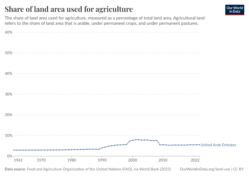
Share of land area used for agriculture
What you should know about this indicator

Agricultural land refers to the share of land area that is arable, under permanent crops, and under permanent pastures. Arable land includes land defined by the FAO as land under temporary crops (double-cropped areas are counted once), temporary meadows for mowing or for pasture, land under market or kitchen gardens, and land temporarily fallow. Land abandoned as a result of shifting cultivation is excluded. Land under permanent crops is land cultivated with crops that occupy the land for long periods and need not be replanted after each harvest, such as cocoa, coffee, and rubber. This category includes land under flowering shrubs, fruit trees, nut trees, and vines, but excludes land under trees grown for wood or timber. Permanent pasture is land used for five or more years for forage, including natural and cultivated crops.

Limitations and exceptions: The data are collected by the Food and Agriculture Organization of the United Nations (FAO) from official national sources through annual questionnaires and are supplemented with information from official secondary data sources. The secondary sources cover official country data from websites of national ministries, national publications and related country data reported by various international organizations.. The FAO tries to impose standard definitions and reporting methods, but complete consistency across countries and over time is not possible. Thus, data on agricultural land in different climates may not be comparable. For example, permanent pastures are quite different in nature and intensity in African countries and dry Middle Eastern countries. Data on agricultural employment, in particular, should be used with caution. In many countries much agricultural employment is informal and unrecorded, including substantial work performed by women and children. To address some of these concerns, this indicator is heavily footnoted in the database in sources, definition, and coverage.

Statistical concept and methodology: Agriculture is still a major sector in many economies, and agricultural activities provide developing countries with food and revenue. But agricultural activities also can degrade natural resources. Poor farming practices can cause soil erosion and loss of soil fertility. Efforts to increase productivity by using chemical fertilizers, pesticides, and intensive irrigation have environmental costs and health impacts. Excessive use of chemical fertilizers can alter the chemistry of soil. Pesticide poisoning is common in developing countries. And salinization of irrigated land diminishes soil fertility. Thus, inappropriate use of inputs for agricultural production has far-reaching effects.

Agricultural land is also sometimes classified as irrigated and non-irrigated land. In arid and semi-arid countries agriculture is often confined to irrigated land, with very little farming possible in non-irrigated areas. Land abandoned as a result of shifting cultivation is excluded from Arable land.

Data on agricultural land are valuable for conducting studies on a various perspectives concerning agricultural production, food security and for deriving cropping intensity among others uses. Agricultural land indicator, along with land-use indicators, can also elucidate the environmental sustainability of countries' agricultural practices.

Total land area does not include inland water bodies such as major rivers and lakes. Variations from year to year may be due to updated or revised data rather than to change in area.

Source
Multiple sources compiled by World Bank (2024) – processed by Our World in Data
Last updated
May 20, 2024
Next expected update
May 2025
Date range
1961–2021
Unit
% of land area

Sources and processing

This data is based on the following sources

The World Development Indicators (WDI) is the primary World Bank collection of development indicators, compiled from officially-recognized international sources. It presents the most current and accurate global development data available, and includes national, regional and global estimates.

Retrieved on
May 20, 2024
Citation
This is the citation of the original data obtained from the source, prior to any processing or adaptation by Our World in Data. To cite data downloaded from this page, please use the suggested citation given in Reuse This Work below.
World Bank's World Development Indicators (WDI).

How we process data at Our World in Data

All data and visualizations on Our World in Data rely on data sourced from one or several original data providers. Preparing this original data involves several processing steps. Depending on the data, this can include standardizing country names and world region definitions, converting units, calculating derived indicators such as per capita measures, as well as adding or adapting metadata such as the name or the description given to an indicator.

At the link below you can find a detailed description of the structure of our data pipeline, including links to all the code used to prepare data across Our World in Data.

Read about our data pipeline

Reuse this work

  • All data produced by third-party providers and made available by Our World in Data are subject to the license terms from the original providers. Our work would not be possible without the data providers we rely on, so we ask you to always cite them appropriately (see below). This is crucial to allow data providers to continue doing their work, enhancing, maintaining and updating valuable data.
  • All data, visualizations, and code produced by Our World in Data are completely open access under the Creative Commons BY license. You have the permission to use, distribute, and reproduce these in any medium, provided the source and authors are credited.

Citations

How to cite this page

To cite this page overall, including any descriptions, FAQs or explanations of the data authored by Our World in Data, please use the following citation:

“Data Page: Share of land area used for agriculture”. Our World in Data (2024). Data adapted from Food and Agriculture Organization of the United Nations (via World Bank). Retrieved from https://ourworldindata.org/grapher/share-of-land-area-used-for-agriculture [online resource]
How to cite this data

In-line citationIf you have limited space (e.g. in data visualizations), you can use this abbreviated in-line citation:

Multiple sources compiled by World Bank (2024) – processed by Our World in Data

Full citation

Multiple sources compiled by World Bank (2024) – processed by Our World in Data. “Share of land area used for agriculture” [dataset]. Food and Agriculture Organization of the United Nations (via World Bank), “World Development Indicators” [original data]. Retrieved November 21, 2024 from https://ourworldindata.org/grapher/share-of-land-area-used-for-agriculture