FAQs on the Living Planet Index
The Living Planet Index is one of the most common measures used in biodiversity monitoring. But what is it, and where does this data come from?
The Living Planet Index (LPI) is a measure of biodiversity that is often misinterpreted. In our accompanying article on the Living Planet Index, we describe these misinterpretations in detail, and what it actually tells us about the state of global biodiversity.
In this short page we answer some commonly-asked questions about this measure of biodiversity.
What does the Living Planet Index (LPI) measure?
The Living Planet Index (LPI) provides a measure of wildlife abundance. It measures the average decline in population size since 1970 across a wide range of species.1
What does the Living Planet Index (LPI) not measure?
The Living Planet Index does not measure:
- Number of species lost
- Number of populations or individuals that have been lost
- Number or percentage of species or populations that are declining
- Number of extinctions
What types of species are included?
The LPI only includes data from vertebrate populations. This includes mammals, birds, reptiles, amphibians, and fish. Taxonomic groups including insects, corals, fungi, and plants are not included.
How many species does it cover? What is the geographical range of this coverage?
In its latest report, published in 2024, 34,836 populations across 5,495 species were included. It includes species and populations across all continents. This breakdown is given in the table.
Region | Number of species included |
|---|---|
Global | 5,495 |
Africa | 552 |
North America | 935 |
Latin America & Caribbean | 1,362 |
Asia-Pacific | 768 |
Europe and Central Asia | 619 |
What percentage of known species are included in the LPI?
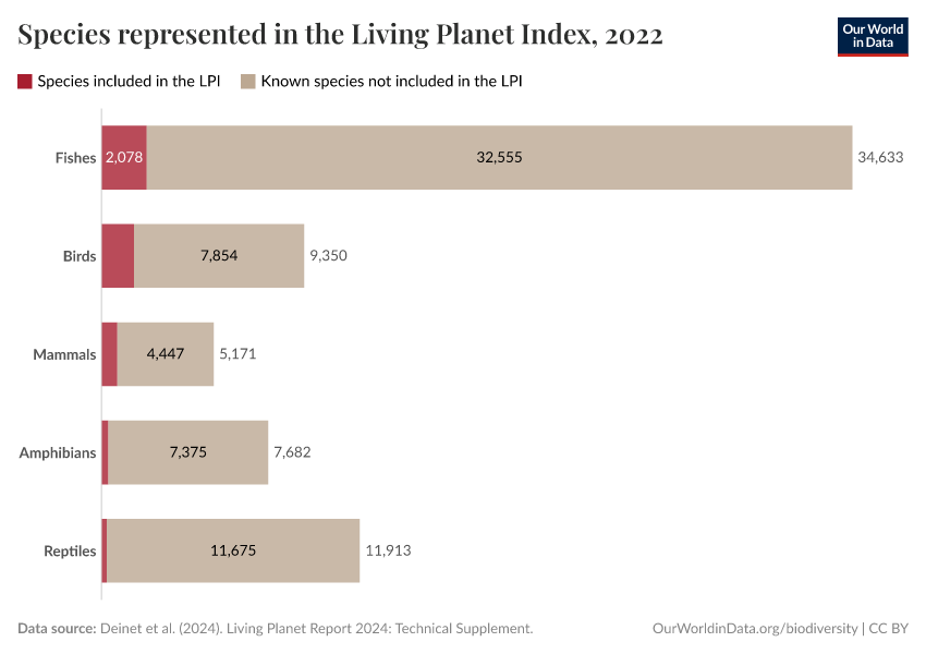
Only vertebrate species are included in the LPI: this includes mammals, birds, reptiles, amphibians and fish. Taxonomic groups including insects, corals, fungi and plants are not included.
Only a small percentage of known species in these groups are included. The number of populations and species from each group is shown in the first chart below. The second shows the percentage of known species that are included.


Where does the data for the LPI come from?
The underlying data for the LPI comes from a combination of published scientific articles, online databases and government reports. To be included, data points must contain a time series of vertebrate populations spanning any number of years from 1970 onwards.
What does the LPI show?
The latest results from the LPI indicate an average decline in the studied wildlife populations of 73% between 1970 and 2020.
Thiis does not mean that we have lost 73% of wildlife over this period. For a clear example of why this is the wrong conclusion, and how the LPI is calculated, see our example here.
Are all studied wildlife populations in decline?
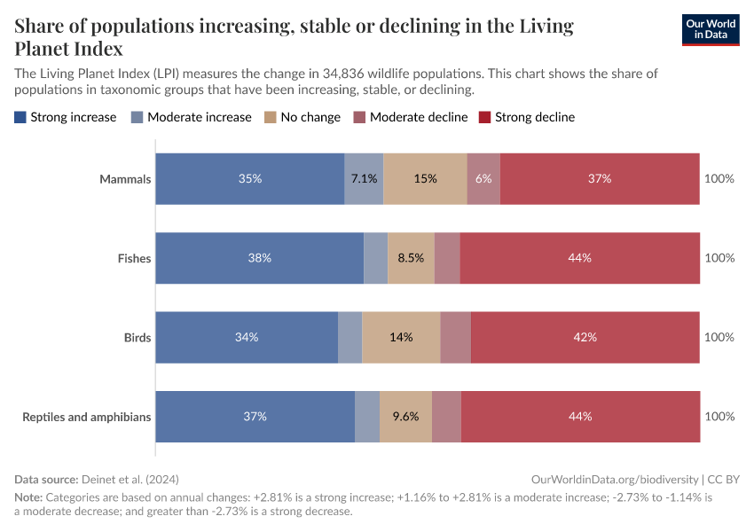
No, the results of the LPI show that around half of the studied populations are stable or are increasing in abundance, while half are declining. The fact that there is such a large average decline suggests that the magnitude of the decline across many populations is much larger than magnitude for increasing populations.

Endnotes
WWF (2024) Living Planet Report 2024 – A System in Peril. WWF, Gland, Switzerland.
Cite this work
Our articles and data visualizations rely on work from many different people and organizations. When citing this article, please also cite the underlying data sources. This article can be cited as:
Hannah Ritchie and Fiona Spooner (2022) - “FAQs on the Living Planet Index” Published online at OurWorldinData.org. Retrieved from: 'https://archive.ourworldindata.org/20251125-173858/faq-living-planet-index.html' [Online Resource] (archived on November 25, 2025).BibTeX citation
@article{owid-faq-living-planet-index,
    author = {Hannah Ritchie and Fiona Spooner},
    title = {FAQs on the Living Planet Index},
    journal = {Our World in Data},
    year = {2022},
    note = {https://archive.ourworldindata.org/20251125-173858/faq-living-planet-index.html}
}
Reuse this work freely
All visualizations, data, and code produced by Our World in Data are completely open access under the Creative Commons BY license. You have the permission to use, distribute, and reproduce these in any medium, provided the source and authors are credited.
The data produced by third parties and made available by Our World in Data is subject to the license terms from the original third-party authors. We will always indicate the original source of the data in our documentation, so you should always check the license of any such third-party data before use and redistribution.
All of our charts can be embedded in any site.