Global deforestation peaked in the 1980s. Can we bring it to an end?
There was a marked acceleration in deforestation in the 20th century. But, global deforestation peaked in the 1980s. Since then, it has slowed.
Since the end of the last great ice age – 10,000 years ago – the world has lost one-third of its forests.1 Two billion hectares of forest – an area twice the size of the United States – has been cleared to grow crops, raise livestock, and use for fuelwood.
In a previous post we looked at this change in global forests over the long-run. What this showed was that although humans have been deforesting the planet for millennia, the rate of forest loss accelerated rapidly in the last few centuries. Half of global forest loss occurred between 8,000BC and 1900; the other half was lost in the last century alone.
To understand this more recent loss of forest, let’s zoom in on the last 300 years. The world lost 1.5 billion hectares of forest over that period. That’s an area 1.5-times the size of the United States.
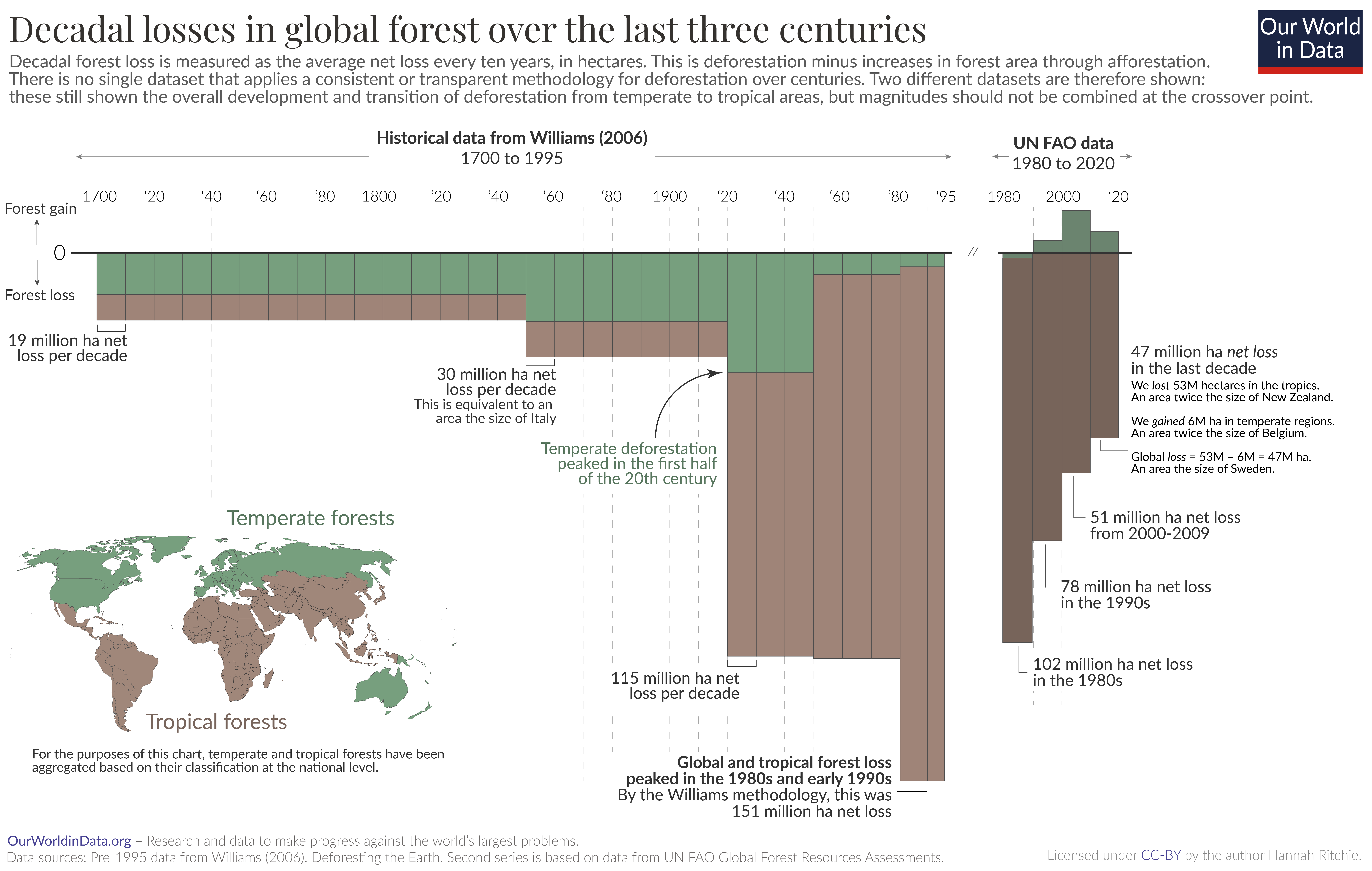
In the chart we see the decadal losses and gains in global forest cover. On the horizontal axis we have time, spanning from 1700 to 2020; on the vertical axis we have the decadal change in forest cover. The taller the bar, the larger the change in forest area. This is measured in hectares, which is equivalent to 10,000 m².
Forest loss measures the net change in forest cover: the loss in forests due to deforestation plus any expansion of forest through afforestation.2
Unfortunately there is no single source that provides consistent and transparent data on deforestation rates over this period of time. Methodologies change over time, and estimates – especially in earlier periods – are highly uncertain. This means I’ve had to use two separate datasets to show this change over time. As we’ll see, they produce different estimates of deforestation for an overlapping decade – the 1980s – which suggests that these are not directly comparable. I do not recommend combining them into a single series, but the overall trends are still applicable and tell us an important story about deforestation over the last three centuries.
The first series of data comes from Williams (2006), who estimates deforestation rates from 1700 to 1995.3 Due to poor data resolution, these are often given as average rates over longer periods – for example, annual average rates are given over the period from 1700 to 1849, and 1920 to 1949. That’s why these rates look strangely consistent over long period of time.
The second series comes from the UN Food and Agriculture Organization (FAO). It produces a new assessment of global forests every 5 years.4

The rate and location of forest loss changed a lot. From 1700 to 1850, 19 million hectares were being cleared every decade. That’s around half the size of Germany.
It was most temperate forests across Europe and North America that were being lost at this time. Population growth meant that today’s rich countries needed more and more resources such as land for agriculture, wood for energy, and for construction.5
Moving into the 20th century there was a stepwise change in demand for agricultural land and energy from wood. Deforestation rates accelerated. And the hotspot of deforestation changed from the equivalent to the area of South Africa. This increase was mostly driven by tropical deforestation as countries across Asia and Latin America.
Global forest loss appears to have reached its peak in the 1980s. The two sources do not agree on the magnitude of this loss: Williams (2006) estimates a loss of 150 million hectares – an area half the size of India – during that decade.
Interestingly, the UN FAO 1990 report also estimated that deforestation in tropical ‘developing’ countries was 154 million hectares. But, it estimated that regrowth of old forests offset some of these losses, leading to a net loss of 102 million hectares.6
The latest UN Forest Resources Assessment estimates that the net loss in forests has declined in the last three decades, from 78 million hectares in the 1990s to 47 million hectares in the 2010s.
This data maps an expected pathway based on what we know from how human-forest interactions evolve.
As we explore in more detail in our related article, countries tend to follow a predictable development in forest cover, a U-shaped curve.7 They lose forests as populations grow and demand for agricultural land and fuel increases, but eventually they reach the so-called ‘forest transition point’ where they begin to regrow more forests than they lose.
That is what has happened in temperate regions: they have gone through a period of high deforestation rates, before a slowing and reversal of this trend.
However, many countries – particularly in the tropics and sub-tropics – are still moving through this transition. Deforestation rates are still very high.
Deforestation rates are still high across the tropics
Large areas of forest are still being lost in the tropics today. This is particularly tragic because these are regions with very high concentrations of biodiversity.
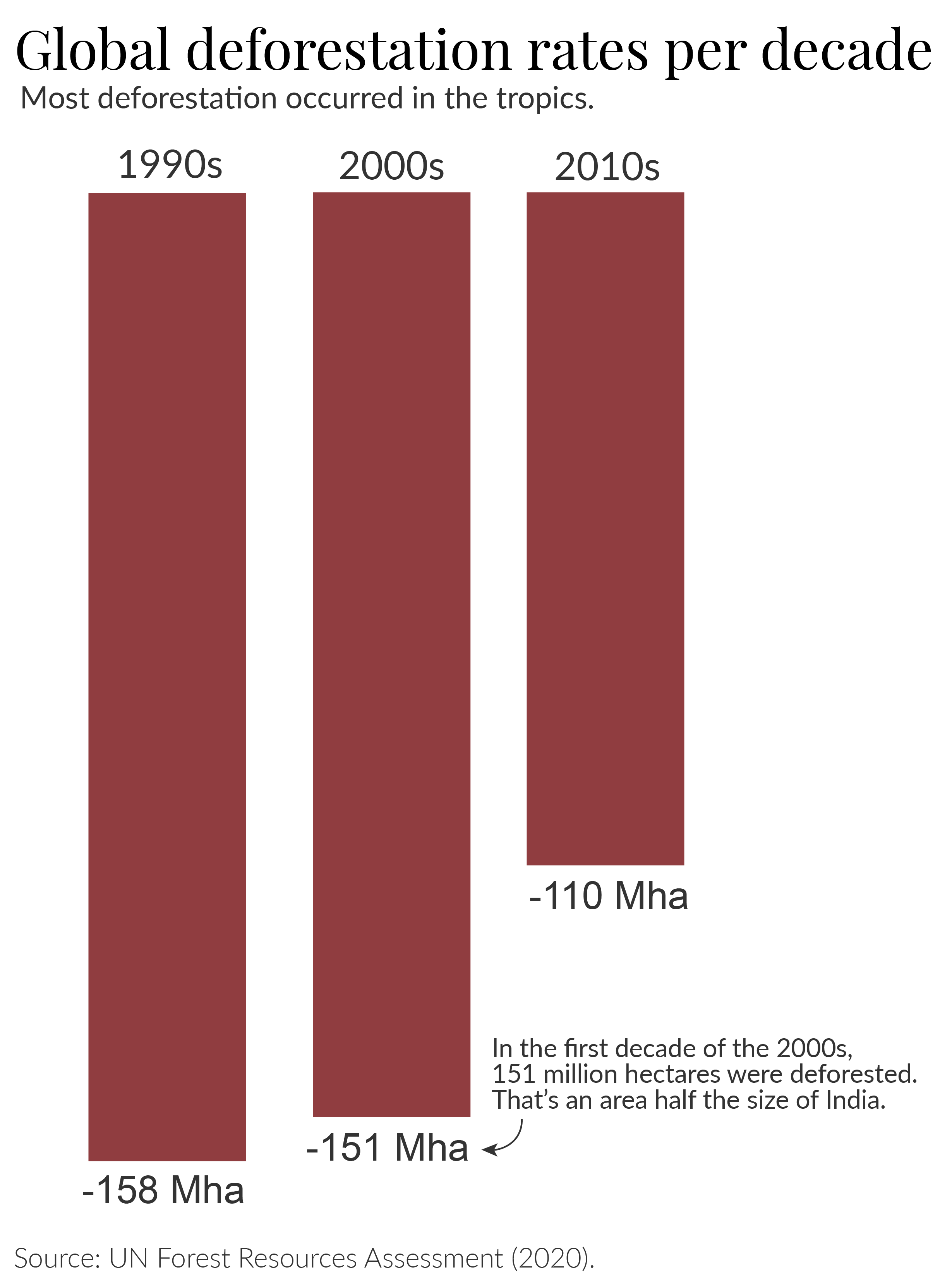
Let’s look at estimates of deforestation from the latest UN Forest report. This shows us raw deforestation rates, without any adjustment for the regrowth or plantation of forests, which is arguably not as good for ecosystems or carbon storage.
This is shown in the chart below.
We can see that the UN does estimate that deforestation rates have fallen since the 1990s. However, there was very little progress from the 1990s to 2000s, and an estimated 26% drop in rates in the 2010s. In 2022, the FAO published a separate assessment based on Remote Sensing methods; it did not report data for the 1990s, but also estimated a 29% reduction in deforestation rates from early 2000s to the 2010s.

This is progress, but it needs to happen much faster. The world is still losing large amounts of primary forests every year. To put these numbers in context: during the 1990s and first decade of the 2000s, an area almost the size of India was deforested.8 Even with the ‘improved’ rates in the 2010s, this still amounted to an area around twice the size of Spain.9
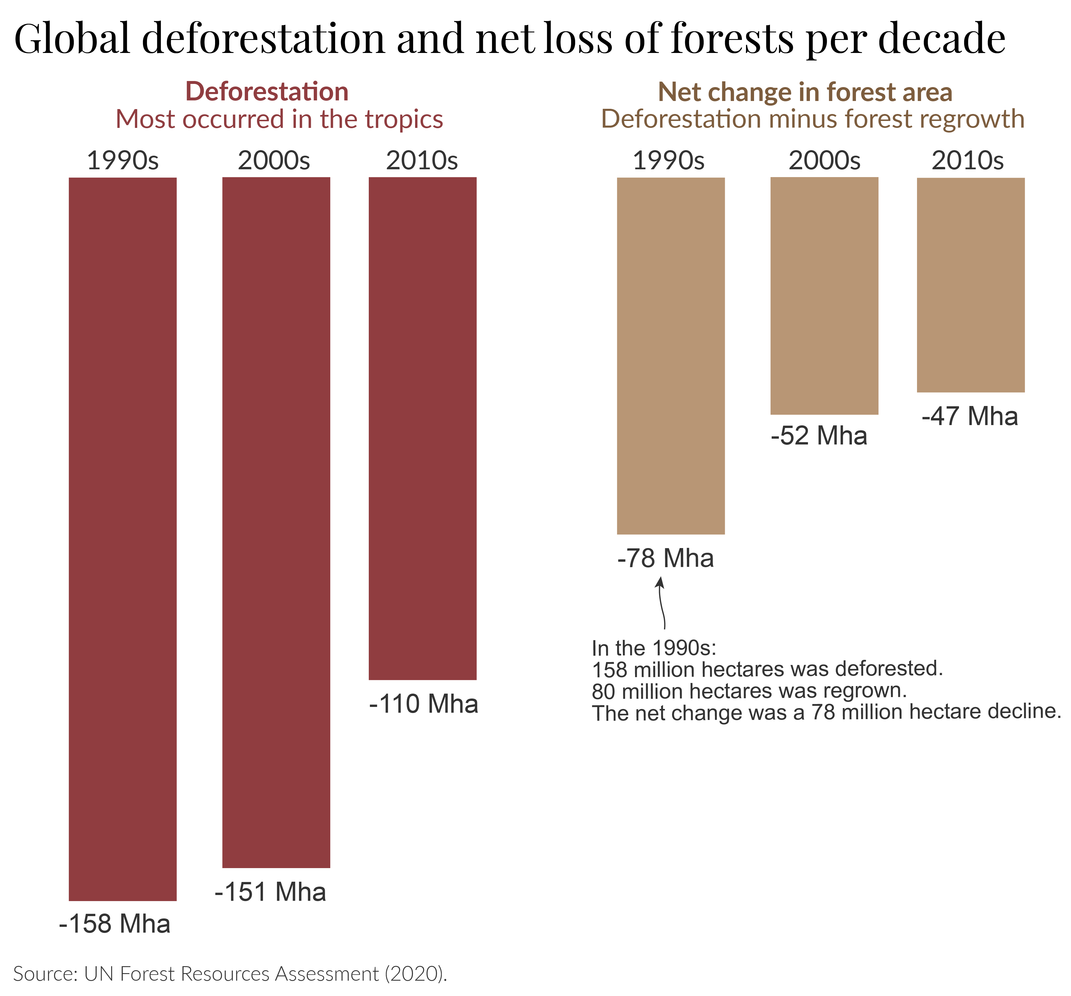
The regrowth of forests is a positive development. In the chart below, we see how this affects the net change in global forests. Forest recovery and plantation ‘offsets’ a lot of deforestation such that the net losses are around half the rates of deforestation alone.

But we should be cautious here: it’s often not the case that the ‘positives’ of regrowing one hectare of forest offset the ‘losses’ of one hectare of deforestation. Cutting down one hectare of rich, tropical rainforest cannot be completely offset by the plantation of forest in a temperate country.
Forest expansion is positive, but does not negate the need to finally end deforestation.
The history of deforestation is a tragic one, in which we not only lost these wild and beautiful landscapes but also the wildlife within them. But, the fact that forest transitions are possible should give us confidence that a positive future is possible. Many countries have not only ended deforestation, but actually achieved substantial reforestation. It will be possible for our generation to achieve the same on the global scale and bring the 10,000 year history of forest loss to an end.
If we want to end deforestation we need to understand where and why it’s happening; where countries are within their transition; and what can be done to accelerate their progress through it. We need to pass the transition point as soon as possible, while minimising the amount of forest we lose along the way.
In this article I look at what’s driving deforestation: that helps us understand what we need to do to solve it.
Forest definitions and comparisons to other datasets
There is no universal definition of what a ‘forest’ is. That means there are a range of estimates of forest area, and how this has changed over time.
In this article, in the recent period I have used data from the UN’s Global Forest Resources Assessment (2020). The UN carries out these global forest stocktakes every five years. These forest figures are widely-used in research, policy, and international targets, such as in the Sustainable Development Goals.
The UN FAO has a very specific definition of a forest. It’s “land spanning more than 0.5 hectares with trees higher than 0.5 meters and a canopy cover of more than 10%, or trees able to reach these thresholds in situ.”
In other words, it has criteria for the area that must be covered (0.5 hectares), the minimum height of trees (0.5 meters) and a density of at least 10%.
Compare this to the UN Framework on Climate Change (UNFCCC), which uses forest estimates to calculate land use carbon emissions, and for its REDD+ programme, where low-to-middle income countries can receive finance for verified projects that prevent or reduce deforestation. It defines a forest as having a density of 10-30%, a minimum tree height of 2-5 meters, and a smaller area of 0.1 hectares.
It’s not just forest definitions that vary between sources. What is measured (and not measured) differs too. Global Forest Watch is an interactive online dashboard that tracks ‘tree loss’ and ‘forest loss’ across the world. It measures this in real-time, and can provide better estimates of year-to-year variations in rates of tree loss.
However, the UN FAO and Global Forest Watch do not measure the same thing.
The UN FAO measures deforestation based on how land is used. It measures the permanent conversion of forested land to another use, such as pasture, croplands, or urbanization. Temporary changes in forest cover, such as losses through wildfire, or small-scale shifting agriculture are not included in deforestation figures, because it is assumed that they will regrow. If the use of land has not changed, it is not considered deforestation.
Global Forest Watch (GFW) measures temporary changes in forests. It can detect changes in land cover, but does not differentiate the underlying land use. All deforestation would be considered tree loss, but a lot of tree loss would not be considered as deforestation.
As GFW describes in its definition of ‘forest loss’: “Loss” indicates the removal or mortality of tree cover and can be due to a variety of factors, including mechanical harvesting, fire, disease, or storm damage. As such, “loss” does not equate to deforestation.”
We therefore cannot directly compare these sources. This article from Global Forest Watch gives a good overview of the differences between the UN FAO and GFW methods.
Since GFW uses satellite imagery, its methods continually improve. This makes its ability to detect changes in forest cover even stronger. But it also means that comparisons over time are more difficult. It currently warns against comparing pre-2015 and post-2015 data since there was a significant methodological change at that time. Note that this is also a problem in UN FAO reports, as I’ll soon explain.
What data from GFW makes clear is that forest loss across the tropics is still very high, and in the last few years, little progress has been made. Since UN FAO reports are only published in 5-year intervals, they miss these shorter-term fluctuations in forest loss. The GFW’s shorter-interval stocktakes of how countries are doing will become increasingly valuable.
One final point to note is that UN FAO estimates have also changed over time, with improved methods and better access to data.
I looked at how net forest loss rates in the 1990s were reported across five UN reports: 2000, 2005, 2010, 2015 and 2020.
Estimated rates changed in each successive report:
- 2000 report: Net losses of 92 million hectares
- 2005 report: 89 million hectares
- 2010 report: 83 million hectares
- 2015 report: 72 million hectares
- 2020 report: 78 million hectares
This should not affect the overall trends reported in the latest report: the UN FAO should – as far as is possible – apply the same methodology to its 1990s, 2000s, and 2010s estimates. However, it does mean we should be cautious about comparing absolute magnitudes across different reports.
This is one challenge in presenting 1980 figures in the main visualization in this article. Later reports have not updated 1980 figures, so we have to rely on estimates from earlier reports. We don’t know whether 1980s rates would also be lower with the UN FAO’s most recent adjustments. If so, this would mean the reductions in net forest loss from the 1980s to 1990s were lower than is shown from available data.
Update note
This article was first published in early 2021. It was updated in September 2023 with further discussion on deforestation trends and comparisons to other datasets.
Endnotes
Estimates vary, but most date the end of the last great ice age to around 11,700 years ago.
Kump, L. R., Kasting, J. F., & Crane, R. G. (2004). The Earth System (Vol. 432). Upper Saddle River, NJ: Pearson Prentice Hall.
Year-to-year data on forest change comes with several issues: either data at this resolution is not available, or year-to-year changes can be highly variable. For this reason, data sources – including the UN Food and Agriculture Organization – tend to aggregate annual losses as the average over five-year or decadal periods.
Williams, M. (2003). Deforesting the earth: from prehistory to global crisis. University of Chicago Press.
The data for 1990 to 2000 is from the altest assessment: the UN’s Global Forest Resources Assessment 2020.
FAO (2020). Global Forest Resources Assessment 2020: Main report. Rome. https://doi.org/10.4060/ca9825en.
Mather, A. S., Fairbairn, J., & Needle, C. L. (1999). The course and drivers of the forest transition: the case of France. Journal of Rural Studies, 15(1), 65-90.
Mather, A. S., & Needle, C. L. (2000). The relationships of population and forest trends. Geographical Journal, 166(1), 2-13.
It estimated that the net change in forests without plantations was 121 million hectares. With plantations included – as is standard for the UN’s forest assessments – this was 102 million hectares.
Hosonuma, N., Herold, M., De Sy, V., De Fries, R. S., Brockhaus, M., Verchot, L., … & Romijn, E. (2012). An assessment of deforestation and forest degradation drivers in developing countries. Environmental Research Letters, 7(4), 044009.
The area of India is around 330 million hectares. The combined losses in the 1990s and 2000s was 309 million hectares. Just 6% less than the size of India.
The area of Spain is around 51 million hectares. Double this area is around 102 million hectares – a little under 110 million hectares.
Cite this work
Our articles and data visualizations rely on work from many different people and organizations. When citing this article, please also cite the underlying data sources. This article can be cited as:
Hannah Ritchie (2021) - “Global deforestation peaked in the 1980s. Can we bring it to an end?” Published online at OurWorldInData.org. Retrieved from: 'https://ourworldindata.org/global-deforestation-peak' [Online Resource]BibTeX citation
@article{owid-global-deforestation-peak,
    author = {Hannah Ritchie},
    title = {Global deforestation peaked in the 1980s. Can we bring it to an end?},
    journal = {Our World in Data},
    year = {2021},
    note = {https://ourworldindata.org/global-deforestation-peak}
}
Reuse this work freely
All visualizations, data, and code produced by Our World in Data are completely open access under the Creative Commons BY license. You have the permission to use, distribute, and reproduce these in any medium, provided the source and authors are credited.
The data produced by third parties and made available by Our World in Data is subject to the license terms from the original third-party authors. We will always indicate the original source of the data in our documentation, so you should always check the license of any such third-party data before use and redistribution.
All of our charts can be embedded in any site.

